Map of Africa by Nicolas Sanson d'Abbeville (c.1738)
This map—engraved by Nicolas Sanson d'Abbeville, the "Father of French Cartography" and Geographer to the King—is a textbook example of 17th-century European geographic knowledge (and lack thereof).
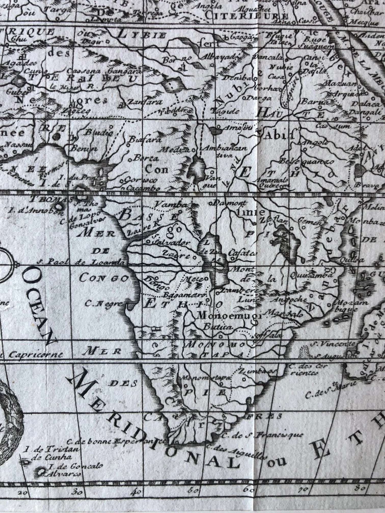
The Mythical Sources of the Nile
See the Nile River originating from two large, side-by-side lakes: Zaire and Zaflan. Just below them are the Monts de la Lune (Mountains of the Moon).
The History: This layout dates back to the 2nd-century geographer Ptolemy. For well over a millennium, Europeans believed the Nile sprang from these twin equatorial lakes fed by alpine snowmelt. It wasn't until the mid-19th century that explorers like Speke, Burton, and Livingstone finally disproved this Ptolemaic model.
The Isla de Ferro Prime Meridian
See the Premier Meridien passing through the Canary Islands (Isles Canaries), specifically near I. de Fer (El Hierro).
The History: Long before Greenwich (England became the international standard in 1884 ) France used its own prime meridian. In 1634, Louis XIII and Cardinal Richelieu decreed that the westernmost point of the known Old World—El Hierro—would serve as the reference line so that all French maps would have a clean, 0-degree baseline.
The "Ethiopian" Atlantic
Ocean Meridional ou Ethiopien (Southern or Ethiopian Ocean).
The History: From antiquity through the 18th century, "Ethiopia" did not just refer to the modern East African nation; it was a blanket term Europeans used for the entire interior of sub-Saharan Africa. Consequently, the vast body of water separating Africa from South America was commonly called the Ethiopian Sea.
A Shift in Cartographic Philosophy
Sanson's work represents a major geopolitical shift in mapmaking. Up until the mid-1600s, the Dutch masters (like Blaeu and Hondius) dominated the trade with highly ornate, colorful maps framed by speculative illustrations and sea monsters. Sanson pioneered the French school of cartography, which favored a cleaner, more scientific aesthetic. While the interior is still full of historical guesswork (like the empires of Monomotapa and Monoemugi), the focus shifted toward geometric accuracy and clean engraving over artistic fantasy.
175mm x 160mm
Copperplate Engraving. Slightly creased.
R3,500