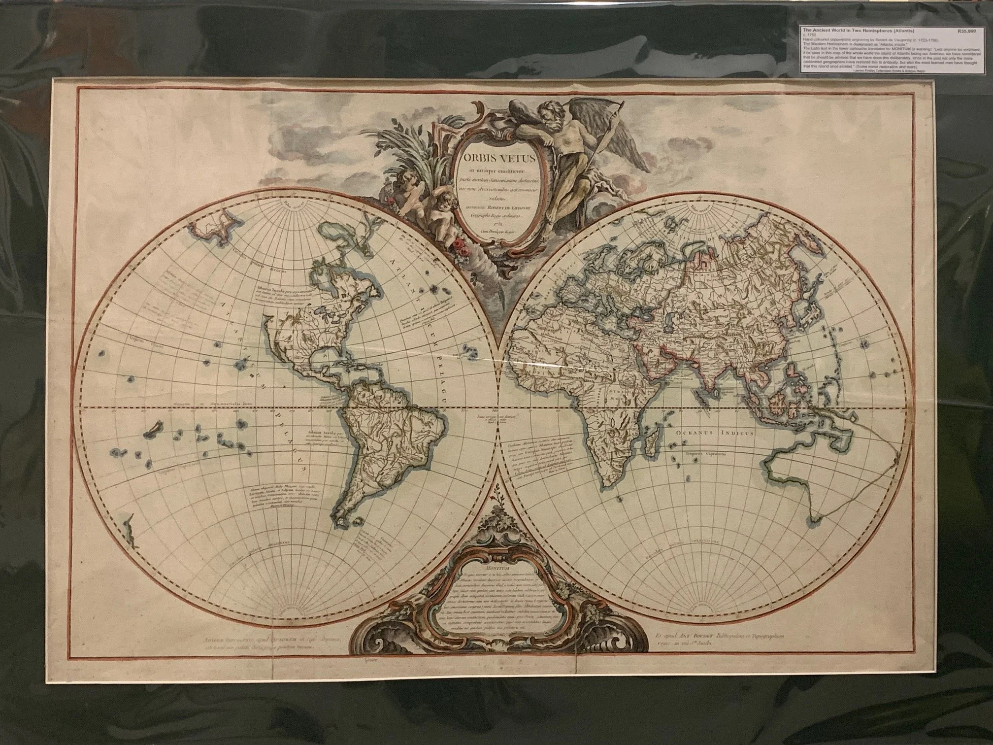
The Ancient World in Two Hemispheres by Robert de Vaugondy c.1752
Hand-coloured copperplate engraving by Robert de Vaugondy (c.1723–1786).
The Western Hemisphere is designated as “Atlantis Insula.”
The Latin text in the lower cartouche translates to “MONITUM (a warning): Lest anyone be surprised, if he sees in this map of the whole world the island of Atlantis facing our America, we have considered that he should be advised that we have done this deliberately, since in the past only the more celebrated geographers have restored this to antiquity, but also the most learned men have thought that this island once existed.”
Some minor restoration and tears.
745mm x 500mm excluding mountboard (unframed).
This historic engraving is a double-hemisphere world map titled "Orbis Vetus in utraque continente juxta mentem Sansonianam distinctus..." ("The Old World in either continent...").
First published in 1752 by the celebrated French Royal Geographer Didier Robert de Vaugondy (alongside his father, Gilles Robert de Vaugondy), this hand-coloured copperplate engraving represents an intriguing 18th-century intellectual exercise: it depicts the known geographical outlines of the mid-1700s, but labels them exclusively with the historical and mythological place names known to the ancients.
The Map's Layout & Geography
The Two Hemispheres: The map balances modern Enlightenment cartography with speculative geography. Because 18th-century exploration was still ongoing, parts of the world are conspicuously incomplete. For instance, the northwest coast of North America (Alaska) is left completely blank, and Australia's coastline is only partially drawn and connected with conjectural dotted lines.
The Decorative Cartouches: Two highly detailed, classical cartouches sit between the hemispheres. The top cartouche features Father Time alongside cherubs (putti), symbolizing the intersection of history, myth, and geography.
The Atlantis Connection
The most fascinating aspect of this map is how it directly links the newly mapped Americas with the classical myth of Atlantis.
1. "Atlantis Insula" (The Island of Atlantis)
Rather than labeling the Western Hemisphere as the Americas, de Vaugondy designates the entire continent of North and South America as "Atlantis Insula" (The Island of Atlantis). Similarly, the Atlantic and Pacific Oceans surrounding it are labeled "Atlanticum Pelagus".
2. The Ten Kingdoms of Neptune
The map divides the Western Hemisphere into ten distinct regions. This division directly references the legend of Atlantis as told by Plato, in which the sea god Neptune divided the great island into ten kingdoms to be ruled by his ten sons (with Atlas as the chief ruler).
3. The "Monitum" (The Warning / Note at the Bottom)
In the lower decorative cartouche, there is a Latin text labeled Monitum (Warning/Notice). It serves as an editorial justification to the reader for equating America with Atlantis.
The translation of this Latin passage explains:
"Lest anyone be surprised, if he sees in this map of the whole world the island of Atlantis facing our America, we have considered that he should be advised that we have done this deliberately, since in the past not only the more celebrated geographers have restored this to antiquity, but also Guillaume Sanson, the wisest of all, had elegantly divided it into ten kingdoms... aligned with the ten sons of Neptune."
The note goes on to argue that while this may seem speculative, ancient Chinese writings and other classical sources hint at the long-standing historical knowledge of this "second continent," making the association of America with Plato's lost continent a legitimate scientific theory of their time.
R25,000