Report on The Geodetic Survey of South Africa 1896
Appears to be complete, but I unfortunately can’t find a collation. xiv, 173 pages in the first part. 291 pages in the second part.
Present: map frontis, and 20 fold out diagrams and illustrations.
This book represents a monumental cornerstone in the history of international cartography, astronomy, and geodesy. Far from being just a dry bureaucratic blue-book, this 1896 report documents a grand scientific ambition: measuring the shape of the Earth from the southern hemisphere.
The Blueprint for the "30th Meridian Arc"
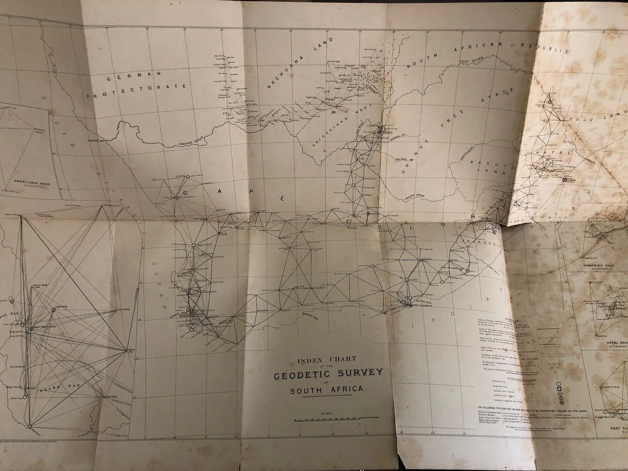
The survey detailed here, executed by Lieutenant-Colonel William George Morris and directed by Sir David Gill, was the foundational anchor for one of the greatest geodetic undertakings in human history: the measurement of the Arc of the 30th Meridian.
Gill’s grand vision was to measure an unbroken triangulated arc stretching all the way from the south of South Africa, through the heart of the African continent, up to Egypt, and connecting with the European networks in Russia. The ultimate goal was to determine the exact size and curvature of the Earth (the geoid). This specific report represents the first completed, highly precise section of that epic continental spine, a project that wasn't fully completed until the 1950s.
David Gill: The Mastermind of Cape Astronomy
David Gill (Her Majesty's Astronomer at the Cape from 1879 to 1907) is a towering figure in Victorian science. Before Gill arrived, mapping in the Cape Colony was fragmented, chaotic, and legally problematic for property boundaries. Gill realized that to map the land properly, you had to look to the stars.
Operating from the Royal Observatory in Cape Town, he fought tooth and nail for over a decade to secure funding from both the Cape and Natal governments to carry out this rigorous geodetic survey, turning the Cape into a world-class hub for astronomical and mathematical precision.
Resolving Maclear’s "Anomalous" Legacy
The title page specifically notes a "Rediscussion of the Survey, executed by Sir Thomas Maclear, F.R.S., in the years 1841–48." This hides a brilliant piece of scientific detective work.
Sir Thomas Maclear (Gill’s predecessor) had previously spent years trying to replicate and extend a famous 18th-century measurement by the French astronomer Abbé de la Caille. La Caille’s early measurements had erroneously suggested that the Earth was shaped differently in the Southern Hemisphere than in the Northern Hemisphere—an anomaly that baffled global scientists for decades. Maclear proved La Caille's calculations were skewed by the gravitational pull of nearby mountains (plumb-line deflection). By "rediscussing" and re-calculating Maclear’s 1840s data with new mathematical models, Gill and Morris finally harmonized South African geography with the rest of the scientific world.
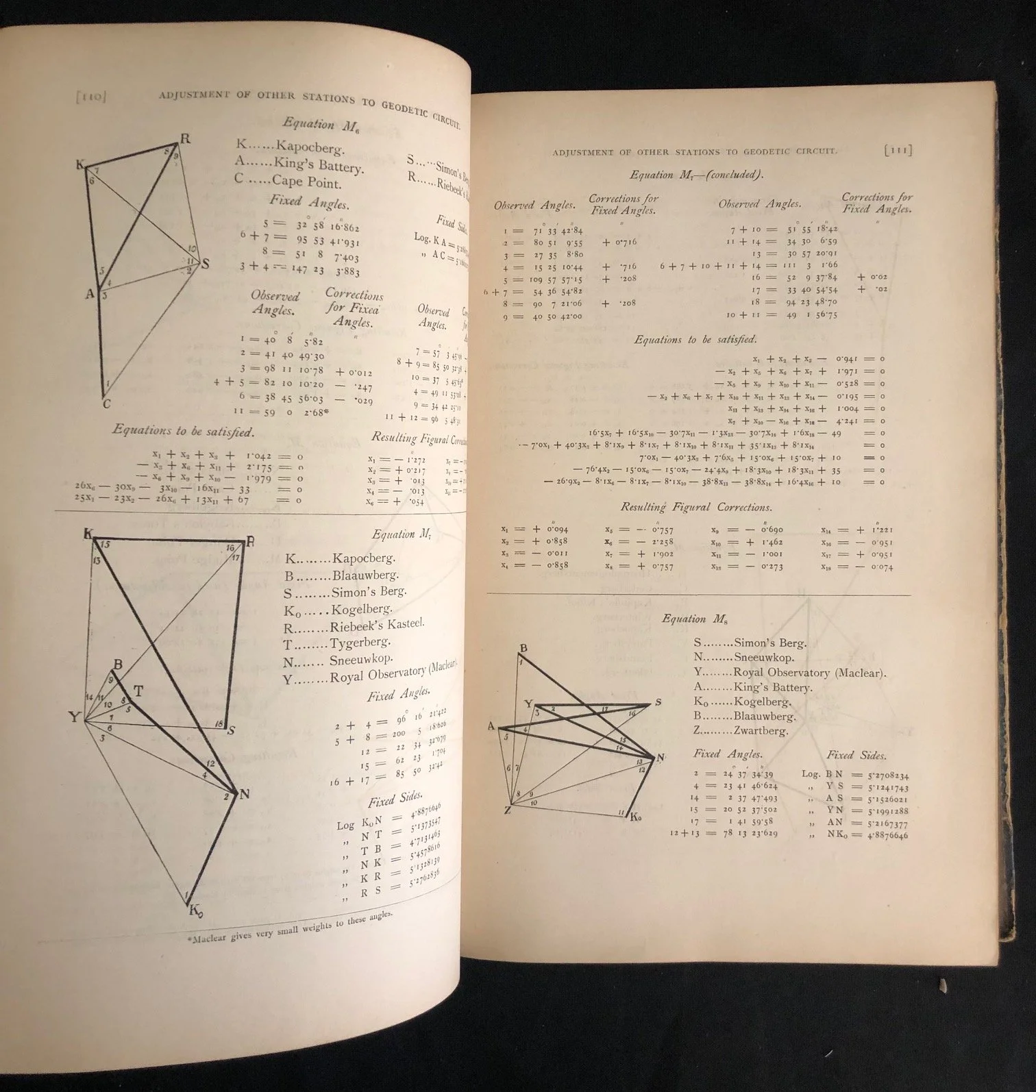
The Unsung Hero: Lieutenant-Colonel Morris
While David Gill directed the project from his study at the Observatory, Lieutenant-Colonel William George Morris of the Royal Engineers was the man on the ground. For nearly a decade (1883–1892), Morris led field parties across rugged mountain peaks, semi-arid deserts, and uncharted terrain, setting up beacons and taking painstaking angular measurements using heavy, delicate astronomical theodolites. The sheer physical endurance required to achieve the mathematical perfection published in this 1896 volume is staggering.
Foxed; binding broken; tears; incorrectly folded.
215mm x 320mm x 40mm
R5,000