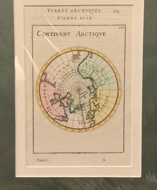
The Arctic
1683
By Alain Manesson Mallet (1630-1706).
Published in Paris.
Hand coloured copperplate engraving from the book ‘Description de L'Univers’, published in Paris.
Mallet was a French cartographer and engineer. He was a Sergeant-Major in the artillery and later Inspector of Fortifications in the army of Louis XIV. Upon retirement from the military he became a cartographer.
120mm x 182mm excluding mountboard
R1,250
This map is "Continent Arctique" (Figure XCIX), created by the French cartographer, engineer, and military strategist Allain Manesson Mallet. It was published in Paris in 1683 as part of his influential 5-volume geographical encyclopedia, Description de l'Univers.
Key Historical & Cartographic Highlights
1. Polar Projection (North Pole at the Center)
The map uses a polar azimuthal projection, centering directly on the North Pole (Pôle Arctique) with radiating lines of longitude (meridians) and concentric circles of latitude. This perspective was pioneered for the region by Gerardus Mercator in 1595 to depict the polar hemisphere in a single circular view.
2. The Legacy of the "Phantom" Four Polar Islands
Mercator’s 16th-century map famously depicted four massive, symmetrical landmasses surrounding a magnetic mountain at the North Pole (Rupes Nigra). By 1683, European exploration had debunked that theory, so Mallet left the central polar sea empty, labeling it simply as Terre Inconnue (Unknown Land) surrounded by the Cercle Polaire Arctique (Arctic Circle).
3. Search for the Northwest & Northeast Passages
Northwest Passage (Amerique side): To the left, North America (Amerique) fades into uncharted space. The region around Hudson Bay (Baye de Hudson) and Davis Strait (Détroit de Davis) reflects 17th-century attempts by explorers like Martin Frobisher, Henry Hudson, and William Baffin to find a navigable trade route to Asia through frozen northern waters.
Northeast Passage (Asie side): Across the top right, Asia (Asie) extends toward Svalbard (Spitsberg) and Nova Zembla (Nouvelle Zemble). Dutch navigator Willem Barentsz had explored Nova Zembla in the 1590s, but the full Siberian coastline remained largely unmapped by Western cartographers until Vitus Bering's expeditions in the 18th century.
4. Historical Place Names & Regional Geopolitics
Greenland (Groenland / Frisland): Depicted with relatively high detail for the era, shaped by centuries of Scandinavian and Dutch whaling and fishing voyages.
Muscovy (Moscovie): European Russia is designated as Moscovie, reflecting the geopolitical nomenclature before Peter the Great formally proclaimed the Russian Empire in 1721.
Iceland (Islande): Prominently featured between Greenland and northern Europe.
5. Allain Manesson Mallet's Publishing Legacy
Mallet (1630–1706) served as a military engineer for King Louis XIV of France. His Description de l'Univers was one of the most widely read illustrated geographical works of the late 17th century. It was celebrated for its copperplate engravings, compact size, and accessible summaries of global geography, military fortification, and history.