Ontdekkingsreizen van den Nieuweren Tijd - Africa ("Voyages of Discovery of Africa") 1871
By Dr. Cornelius Marius Kan
Published in Utrecht by J.L. Beijers in 1871.
Paperback bound into an elementary binding.
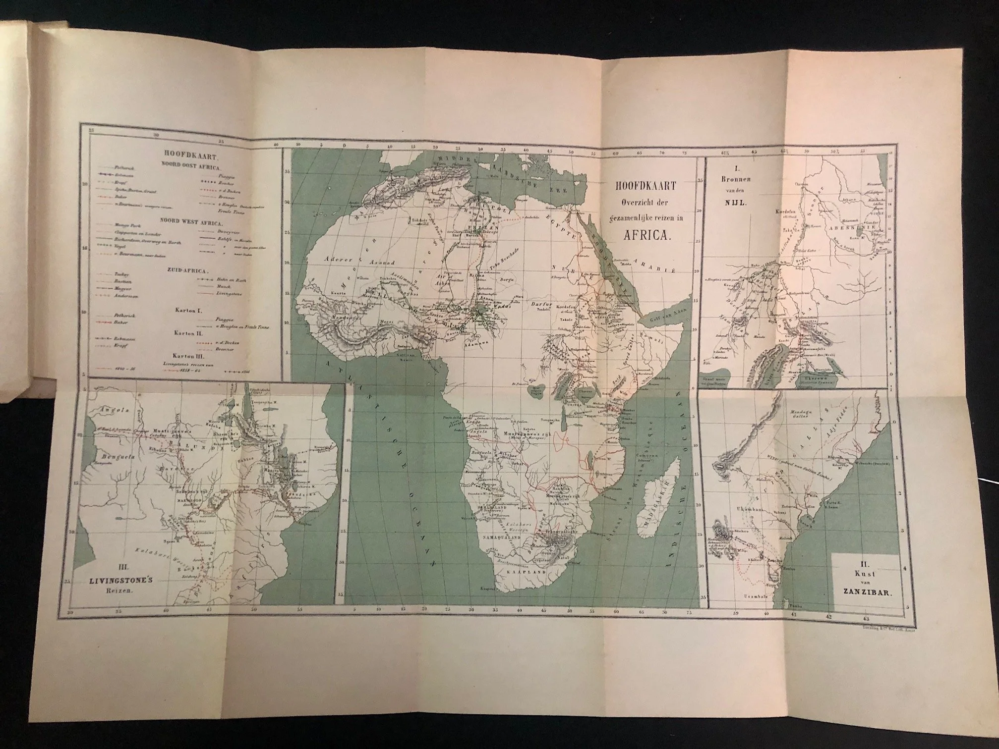
Complete with map (which features the phantom Kong mountain range).
The Mountains of Kong are a legendary mountain range charted on maps of Africa from 1798 through to at least the late 1880s. The mountains were once thought to begin in West Africa near the highland source of the Niger River, close to Tembakounda in Guinea, then continue east to the equally legendary Mountains of the Moon in Central Africa, thought to be where the White Nile had its source. None of these mountains actually exist.
Preceding the "Scramble for Africa"
Published in 1871, this book caught Africa at a definitive cartographic and political turning point. This was three years before Henry Morton Stanley’s landmark trans-Africa expedition (1874–1877) and more than a decade before the Berlin Conference (1884–1885) formally ignited the "Scramble for Africa."
Kan’s work served as an exhaustive contemporary synthesis of what European geographers then knew about the continent's interior, tracking the mapping of regions that Europeans still largely viewed as blank spaces or "the dark continent" just before the floodgates of intense colonial division opened.
Written by the Father of Dutch Geography
The author, Dr. C. M. Kan (1837–1919), is a monumental figure in the history of education and cartography. At the time this book was published in 1871, he was working as a high school teacher in Utrecht. However, just six years later in 1877, the University of Amsterdam appointed Kan as the very first Professor of Geography in the Netherlands.
Because Kan believed that physical and human geography were too distinct to be mastered by a single individual, his eventual retirement directly caused the university to split the discipline into two chairs. This structural division fundamentally shaped the unique analytical trajectory of modern Dutch geography.
A Catalyst for the KNAG
Kan’s research for volumes like this one made him acutely aware of how far behind the Netherlands was in international exploration and geographic science compared to Britain, France, or Germany. Driven by this realization, Kan became one of the primary founding forces behind the KNAG (Koninklijk Nederlands Aardrijkskundig Genootschap / Royal Dutch Geographical Society) in 1873. The society used foundational overviews exactly like this 1871 text to rally public and state support for major Dutch scientific and colonial expeditions, particularly to the Dutch East Indies and parts of South America.
142mm x 230mm x 25mm
R2,500